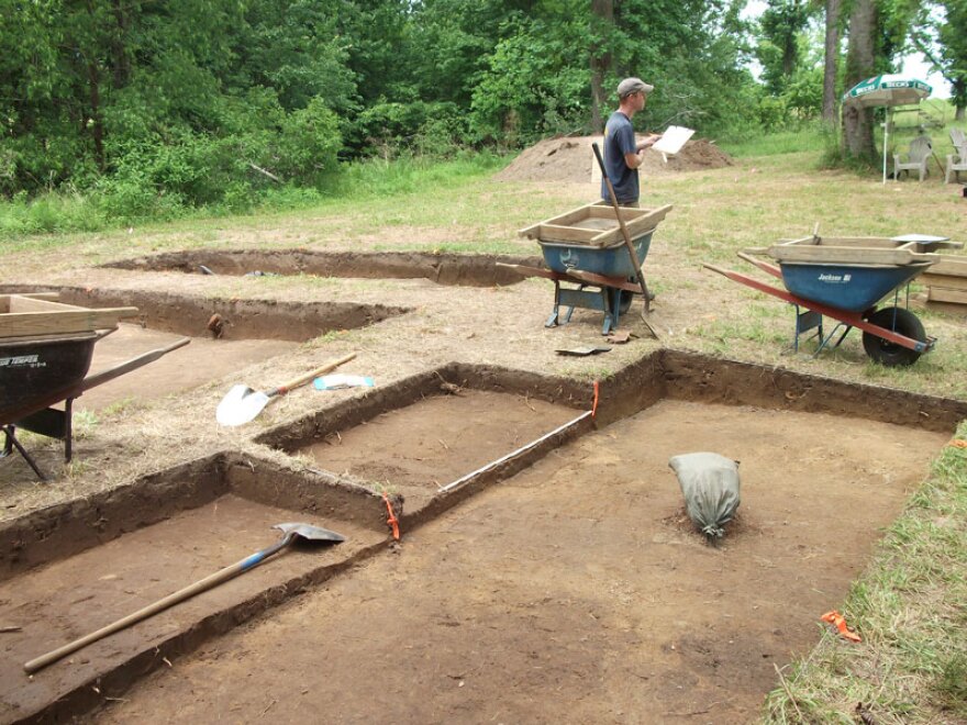
Clues are being uncovered at an archeological site in Bertie County that may reveal what happened to the Lost Colony of Roanoke.
America's history starts with a mystery. Today on the Down East Journal, researchers are closer to finding out what happened to the Lost Colony. In 1587, a group of 117 English settlers arrived at Roanoke Island, in what is now Dare County on the Outer Banks of North Carolina. Later that year, the governor of the new colony John White sailed back to England to gather supplies, but got delayed. When he returned three years later, the colonists had inexplicably disappeared. The only clue was a tree carved with the word “Croatoan.”
“John White knew what the word meant. It was not a mystery to him.”
Phil Evans is the President of the First Colony Foundation, a non-profit research organization.
“it’s just that he never got there to look for the colonist. A storm blew up and it made it impossible for him to search there. But he had also said at the same time that the colonists had talked about going 50 miles inland.”
To this day, no one knows exactly what happened to the first European settlement in the New World. But archeologists are uncovering artifacts at a site in Bertie County to try and piece the puzzle together.

It started in 2012 upon the discovery of hidden clues on the centuries old Virginia Pars map, created by none other than John White.
“We were actually doing some research trying to find out more about the Native American town, the Carolina Algonquian town down on the Pamlico called Secotan. The Virginia Pars map at the British Museum actually has two pieces of paper applied to it, which the British Museum calls patches.”
The first patch appeared to be covering a location on the Pamlico River, while the other was concealing a location where the Chowan and Roanoke Rivers join in northeastern North Carolina.
“So we asked the British Museum to examine the map and they agreed and one of the things they did was place the map on a light table, basically a box with a light under it to project light up through it and when they did, surprisingly, this patch on the northern part of the map appeared a blue and red symbol.”
Evans says the hidden mark signifies the presence of a fortification. The question being does the symbol have any connection to the lost colony of Roanoke?
“Does it cover up something planned and then abandoned, or is it hiding something? That’s part of the mystery of the map and part of the reason why we’re trying to look at archeological sites in that area to see if in fact there was anything there they covered up.”

Leaving the First Colony Foundation with more questions than answers, researchers poured over other maps of nearby archeological sites and identified a target area believed to be the location of the fort symbol. The search lead them to the site in Bertie County, near Salmon Creek close to the Merry Hill community.
“There is the Chowan River on one side, and sort of swampy area on the other side, it’s grassed, it’s quiet. It’s far, far from any paved road.”
In 2013, archeologist started digging at the site, not inconsequently about 60 miles from where the original settlers were on Roanoke Island. Less than a quarter of an acre has been excavated so far, and already they’re uncovering bits of metal from guns, wrought nails, and a piece of iron called a tenterhook. But the most significant artifacts are fragments of ceramic.
“Archeologists and curators are best able to date a site by determining the manufacturer and use dates of early ceramics. The most diagnostic artifacts for us have been two types: one is a north Devon baluster shaped jar. The jar was used to transport food aboard ships of exploration and colonization and discovery. They’re sometimes called fish jars because they were packed with dry fish.”
Another type of ceramic found at the site, possibly connecting these centuries’ old artifacts with early European colonists, is called border ware.

“It’s a type of kitchen ware, domestic ceramic, that was made on the border of Surrey and Hampshire in England. And was a common kitchen item something that people in the Elizabethan period, people who were Sir Walter Raleigh’s colonies would have used daily to cook, serve and eat their food.”
Since excavation began, Evans says dozens of European artifacts have been uncovered. Archeologist are also finding Native American pottery pieces, indicating that early settlers most likely made contact with the Algonquian tribes in the area.
“There’s going to be contact, there’s going to be interchange, there’s going to be cooperation. And of course, there’s also going to be conflict. So finding the Native American artifacts and the European artifacts in proximity is entirely to be expected.”
Over the past two years, on and off digs at the site have taken place. The most recent excavation started in July and lasted four weeks. Archeologists are trying to determine the size of the settlement, and exactly how it’s laid out. But there’s still a lot of ground to cover. Evans estimates they’ve only unearthed about a tenth of the site.
“I think we need to be careful to say we found the Lost Colony of Roanoke and I think we’re saying that very clearly. We’ve found evidence of Elizabethans on this site. Our working hypothesis is that these people we’re finding the presence of are members of the 1587 colony, which has become known as the Lost Colony. But we’re not finding the whole colony, we’re finding a small portion of it.”

Evans is reluctant to say that the mystery of the Lost Colony is solved. After all, it’s possible the artifacts recovered from the Bertie County site were traded or scavenged by Native Americans. Though, Evans says that’s unlikely because they had all the tools and weapons they needed.
Obviously, there are still many questions that archeologist hope to answer. Like did these colonists drive out the Algonquian tribe? Or did pressure from other Native Americans cause these settlements to disappear? For now, the answers to these questions may lie 18 to 24 inches beneath the soil. Evans says digging at the site will resume in October and, depending on funding, could continue for at least five years.


